, Capertee area.")
Date: Sunday 15th May 2016
Description/Location: Airly Village (fomer), Capertee area.
Leaders: Joby & John Mitchell + Annette & Peter Bruce
Report: Joby Mitchell
Images: Hans Staub, Renee Hill, Joby Mitchell, Annette Bruce, Anne-Marie Stanford, Margaret Madden
Map Ref: Glen Alice 8931-4N 2nd Edition NPWS
brochure: Mugil Murum-Ban State conservation Area Carne’s map of 1903: showing Tunnels and tramways, Mt Airly NSW ‘The Shale Railways of NSW’t. Author: GH Eardley & EM Stephens Torbane Tramways – sketch map
The sky in the morning indicated, Shepherd’s take warning, however these bushwalkers paid no heed to this warning, but only kept their finger on the button of their camera’s to capture the reddened sunrise, with fingers crossed the weather was on our side. A pleasant 20-24 degrees.
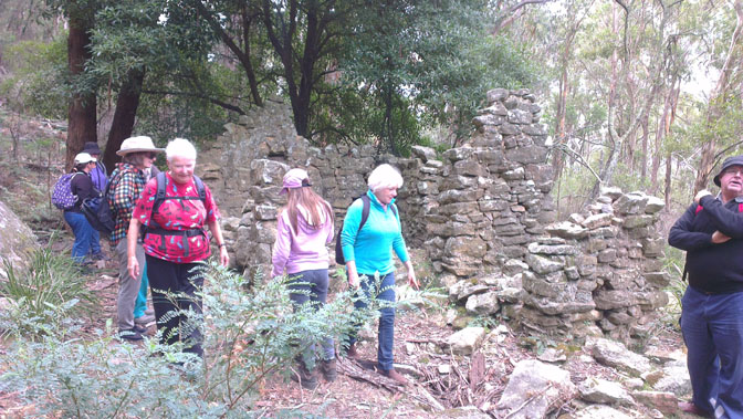
Perfect for a walk along the Tramway Trail at the former village of Mt Airly. After meeting up and carpooling in Mudgee then Capertee, a keen group, of 28 members and visitors enjoyed some refreshments then started out to explore- as per the NPWS brochure: ‘Tramway Trail – follows the old shale mine tramway route around the contour of the former Mt Airly village and through the ruins. The distance was approx. 8klm if you included the turnaround point (a 30+ metre cliff face) which gave way to spectacular views of the valleys below and return via the same route.
Capertee, Airly village area is approx. 60klm from Mudgee and off the Castlereagh Highway on the Glen Davis road, part of the Western Coalfields where and underground coal mine is located. (Airly). Families had built their homes amongst rugged sandstone cliffs of the mountain during the 1890’s. A few homes remain-ruins. Whilst mining for shale a tunnel was also used to supply coal for the company’s retorting operations. Substantial deposits of torbanite were discovered around the massive mesa of Airly mountain that stands above the Capertee Valley.
Previous to today’s visit a reconnaissance was done with 4 members exploring the area before the group came through, with some interesting history and images. Peter Bruce carried his recently purchased book ‘The Shale Railways of NSW’, with railway history around with him so comparisons could be made. From the records it has been noted that some ‘former & current members’ had visited these ruins back in 2001 (over 15 yrs ago). Euni Marskell was one of the members that could note only some minor deterioration of the sites. (Euni has 2001 photos). Current photos from many members have been shared on the facebook page.